The world is becoming increasingly data-driven, and at the forefront of this revolution is geospatial data. From urban planning to climate change mitigation, from precision agriculture to disaster response, geospatial information is shaping our understanding of the world and driving innovations that transform our lives.
However, raw data alone is not enough. To unlock its true potential, this data needs to be accurately annotated, a process that has become a cornerstone of artificial intelligence (AI) and machine learning (ML) development in the geospatial domain.
The Importance of Geospatial Data Annotation
As we stand on the brink of a new era in technology, the importance of geospatial data annotation cannot be overstated. It’s the key that unlocks the door to smarter cities, more efficient resource management, and a deeper understanding of our planet’s complex systems.
This is where companies like Keymakr, under the leadership of CEO Michael Abramov, are making a significant impact.
“Geospatial data annotation is not just about labeling images or maps,” says Abramov. “It’s about creating a bridge between raw data and actionable insights. It’s about enabling machines to understand and interpret the world as we do, but at a scale and speed that was previously unimaginable.”
Driving Factors for Geospatial Data Annotation
The rising demand for geospatial data annotation services is driven by several factors. First and foremost is the exponential growth in the volume of geospatial data being generated. Satellites, drones, IoT devices, and even our smartphones are constantly collecting location-based information. According to a report by MarketsandMarkets, the geospatial analytics market is expected to grow from $59.5 billion in 2021 to $107.8 billion by 2026, at a Compound Annual Growth Rate (CAGR) of 12.6%.
The rising demand for geospatial data annotation services is driven by several factors. A study published in the International Journal of Digital Earth found that the volume of Earth observation data is doubling every 12 months, creating an urgent need for efficient annotation methods.
Keymakr’s Role in Geospatial Data Annotation
This data deluge presents both an opportunity and a challenge. While the potential for insights and innovation is immense, the raw data itself is of limited use without proper annotation and labeling. This is where companies like Keymakr come into play, offering specialized human expertise.
Keymakr has built a reputation for handling complex geospatial projects across a wide range of domains. While most of their clients’ projects are under NDA, Abramov explains that their work spans numerous sectors and applications. “Our expertise in geospatial data annotation touches virtually every industry that relies on location-based information,” he says.
“What’s fascinating about the industry is how it connects seemingly disparate niches,” Abramov notes. “The techniques we use to annotate satellite imagery for urban planners might inform our approach to labeling LiDAR data for autonomous vehicles. This cross-pollination of ideas and methodologies is what keeps our work exciting and innovative.”
The Human Element in Geospatial Data Annotation
Regardless of the specific application, one constant remains: the critical importance of human expertise in the annotation process. While AI and machine learning are increasingly being used to assist in annotation tasks, human judgment remains crucial, especially when dealing with complex or ambiguous data.
“Context is key in geospatial data annotation,” Abramov explains. “Only the human eye and expertise can truly identify objects correctly in many scenarios. Our team includes experts in geography, remote sensing, and cartography, ensuring that the annotations are not just accurate, but also contextually relevant.”
This human-centric approach extends to Keymakr’s quality control processes. The company employs a robust system of human validation, where expert annotators review and verify the work at various stages of the process, including the final stages.
“Human validation is a critical step in our workflow,” says Abramov. “It ensures that we maintain the highest standards of accuracy and consistency, even when dealing with large volumes of data. Our expert annotators come to the scene in the final stages, providing that crucial last layer of quality assurance.”
Diverse Types of Geospatial Data
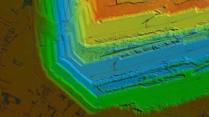
The importance of this approach becomes clear when considering the diverse types of geospatial data that need to be annotated. Satellite imagery, aerial photographs, LiDAR point clouds, and vector data all require different annotation techniques. Keymakr’s proprietary annotation platform, Keylabs, is designed to handle this diversity efficiently, but it’s the human expertise that truly sets the company apart.
“We’ve invested heavily in developing Keylabs to be a versatile and powerful tool for geospatial annotation,”says Abramov. “But it’s not just about having the right technology. It’s about having a team of skilled annotators who understand the nuances of geospatial data and can make informed decisions about how to label and categorize different features.”
Applications of Annotated Geospatial Data
The applications of annotated geospatial data are as diverse as they are impactful. In urban planning, for instance, annotated satellite imagery can help city officials identify areas for development, optimize traffic flow, and plan for sustainable growth. Environmental scientists use annotated geospatial data to track deforestation, monitor wildlife habitats, and study the effects of climate change. In agriculture, annotated aerial imagery helps farmers optimize crop yields and manage resources more efficiently.
Disaster Response and Management
One of the most exciting areas of application is in disaster response and management. Abramov explains, “When a natural disaster strikes, time is of the essence. Annotated geospatial data can help emergency responders quickly assess damage, identify areas most in need of aid, and plan efficient routes for evacuation and resource distribution.”
Autonomous Vehicle Development
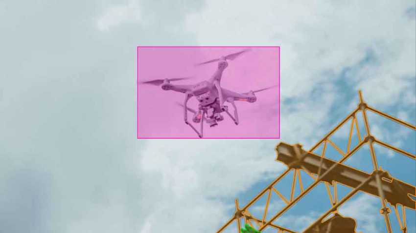
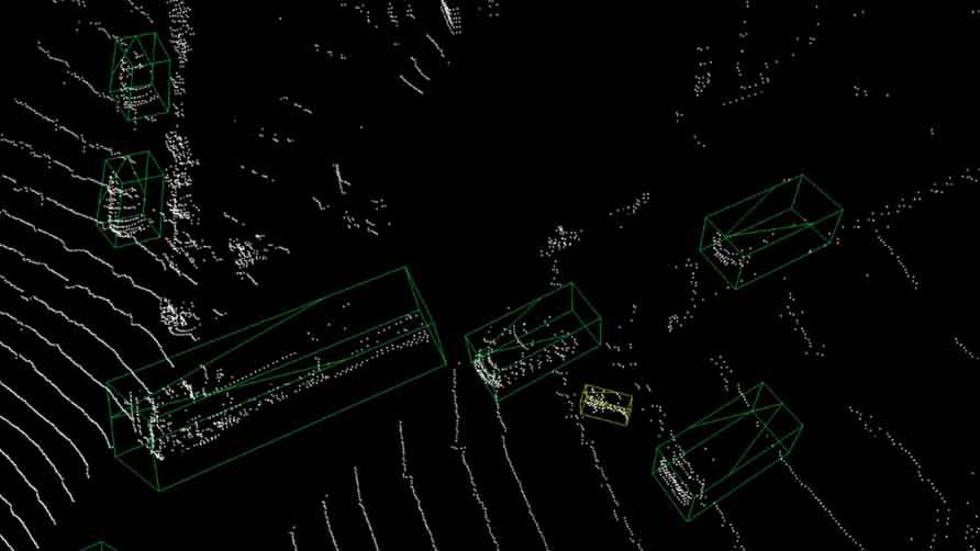
The role of geospatial data annotation in autonomous vehicle development is also significant. High-definition maps with precisely annotated features are crucial for these vehicles to navigate safely and efficiently. “The level of detail required for autonomous vehicle navigation is staggering,” Abramov notes. “Every lane marking, traffic sign, and potential obstacle needs to be accurately annotated. LIDARs and other 3D Point Coud data serve as perfect examples of complex imagery humans currently need to weigh in onl.”
Ensuring Quality and Consistency
As the demand for geospatial data annotation continues to grow, ensuring the quality and consistency of annotations becomes increasingly important. Abramov emphasizes the importance of rigorous quality control processes: “At Keymakr, we’ve implemented a multi-stage quality assurance system. This includes automated checks, peer reviews, and expert validations to ensure that our annotations meet the highest standards of accuracy and consistency.”
The Future of Geospatial Data Annotation
Looking to the future, Abramov sees enormous potential for geospatial AI to address some of the world’s most pressing challenges. “From combating climate change to improving global food security, from managing urbanization to preserving biodiversity – geospatial AI has a role to play in all of these areas,” he says. “And at the heart of all these applications is high-quality, accurately annotated geospatial data.”
As the field continues to evolve, Keymakr is committed to evolving with it. As Abramov puts it, “Every annotation we make, every dataset we process, has the potential to contribute to solutions that can change our world for the better. That’s what makes this field so exciting and rewarding.”